Maps and Exploration
Climate of Australia
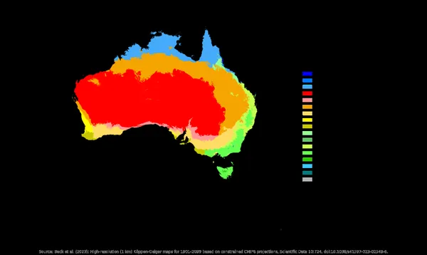
The climate of Australia is the second driest of any continent, after Antarctica. According to the Bureau of Meteorology (BOM), 80% of the land receives less than 600 mm (24 in) of rainfall annually and 50% has even less than 300 mm (12 in). As a whole, Australia has a very low annual average rainfall of 419 mm (16 in). This dryness is governed mostly by the subtropical high pressure belt (subtropical ridge), which brings dry air from the upper atmosphere down onto the continent. This high pressure is typically to the south of Australia in the summer and over the north of Australia in the winter. Hence Australia typically has dry summers in the south and dry winters in the north. The Intertropical Convergence Zone also moves south in Australia's summer, bringing the Australian monsoon to parts of northern Australia. The climate is variable, with frequent droughts lasting several seasons, caused in part by the El Niño-Southern Oscillation. Australia has a wide variety of climates due to its large geographical size. The largest part of Australia is desert or semi-arid. Only the south-east and south-west corners have a temperate climate and moderately fertile soil. The northern part of the country has a tropical climate, varying between grasslands and desert, and subject to some of the largest interannual rainfall variability in the world. Australia holds many heat-related records: the continent has the hottest extended region year-round, the areas with the hottest summer climate, and the highest sunshine duration. Because Australia is separated from polar regions by the Southern Ocean, it is not subject to movements of frigid polar air during winter, of the type that sweep over the continents in the northern hemisphere during their winter. Consequently, Australia's winter is relatively mild, with less contrast between summer and winter temperatures than in the northern continents–though the transition is more dramatically marked in the far inland areas, particularly west of the Great Dividing Range. Seasonal highs and lows can still be considerable. Temperatures have ranged from above 50 °C (122 °F) to as low as −23.0 °C (−9.4 °F). Minimum temperatures are moderated. The El Niño–Southern Oscillation is associated with seasonal abnormality in many areas in the world.
Also on this shelf
Danish Expedition to Queen Louise Land.
Donegal (town).
See also
Uncatalogued shelfText from Wikipedia; plate via Wikimedia Commons. Text CC BY-SA 4.0; plate freely licensed (see Commons). Source record. Images and catalogue data are reproduced from open-access collections.