Natural History
Geography of Antigua and Barbuda
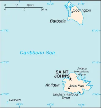
Antigua and Barbuda lie in the eastern arc of the Leeward Islands of the Lesser Antilles, separating the Atlantic Ocean from the Caribbean Sea. Antigua is 650 km (400 mi) southeast of Puerto Rico; Barbuda lies 48 km (30 mi) due north of Antigua, and the uninhabited island of Redonda is 56 km (35 mi) southwest of Antigua. The largest island of Antigua, is 21 km (about a dozen miles) across and 281 km2 (about a hundred square miles) in area. Barbuda covers 161 km2 (62 sq mi) while Redonda encompasses 2.6 km2 (1.0 sq mi). The capital of Antigua and Barbuda is St. John's, located at St. John's Harbour on the northwest coast of Antigua. The principal city of Barbuda is Codrington, located on Codrington Lagoon. In Antigua and Barbuda forest cover is around 18% of the total land area, equivalent to 8,120 hectares (ha) of forest in 2020, down from 10,110 hectares (ha) in 1990.
Also on this shelf
Diadectidae.
Bioregion.
See also
Uncatalogued shelfText from Wikipedia; plate via Wikimedia Commons. Text CC BY-SA 4.0; plate freely licensed (see Commons). Source record. Images and catalogue data are reproduced from open-access collections.