Maritime History
Integrated Coastal Surveillance System
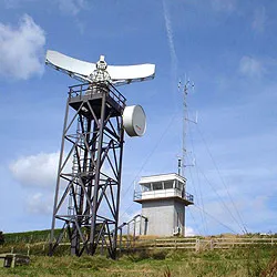
The Integrated Coastal Surveillance System (ICSS) is a coastal surveillance system operated by India with the goal to protect its coastline, ensure regional security, and assist friendly navies by quickly detecting, locating and monitoring maritime activity in the Indian Ocean. The system was developed by the Defence Research and Development Organisation (DRDO) and Bharat Electronics, and forms part of the National Command Control Communication and Intelligence System (NC3I). Although the ICSS was built primarily for coastal and maritime security, the system can also be used for vessel traffic management, harbour surveillance and navigation. The core of the ICSS is a network of remote ground-based radar stations called the Coastal Surveillance Network (CSN). In addition to radars, stations are also fitted with optical sensors, electro-optical sensors, thermal imagers, cameras, meteorological systems, an Automatic Identification System (AIS), a distress alert transmission system (DATS), electronic warfare support measures, and very high frequency (VHF) radio communication systems. The Coastal Surveillance Radar is the primary sensor of the Integrated Coastal Surveillance System, due to which the ICSS itself is sometimes referred to as the Coastal Surveillance Radar System. Coastal Surveillance Radars operate round the clock in all weather conditions and are capable of detecting small vessels such as trawlers, dinghies, fishing vessels, and buoys at sea. Data from the Coastal Surveillance Network is further supplemented by additional inputs from other sources such as the Vessel Traffic Management Systems (VTMS) located at major ports, Long Range Identification and Tracking (LRIT), the Fishing Vessel Monitoring System, and satellite imagery. Data from coastal surveillance radar stations is transmitted in real-time to the nearest Remote Operating Station, which sends the information to one of the four Joint Operations Centres (JOC) at Mumbai, Kochi, Visakhapatnam and Port Blair. The JOCs in turn feed data to the National Command Control Communication and Intelligence System (NC3I) operated by Gurugram-based Information Management and Analysis Centre (IMAC), which is the nodal agency for maritime data fusion. The ICSS project originated from a proposal by the Group of Ministers set up to consider the recommendations of the Kargil Review Committee in 2000.
Also on this shelf
Galata – Museo del mare.
German submarine U-86 (1941).
See also
Uncatalogued shelfText from Wikipedia; plate via Wikimedia Commons. Text CC BY-SA 4.0; plate freely licensed (see Commons). Source record. Images and catalogue data are reproduced from open-access collections.