Maps and Exploration
Anders Bure
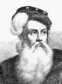
Anders Bure (before his ennoblement Andreas Bureus; 14 August 1571 – 4 February 1646) was a Swedish cartographer, considered the "father of Swedish cartography". He worked in the royal chancery (the precursor to the Government offices) and in 1603 was commissioned to produce a map of the Nordic countries by the future King Charles IX of Sweden. He produced a first map, covering the northern parts of Sweden, in 1611; it was considerably more accurate than earlier attempts at mapmaking and has been called the first real map of Sweden. It was followed by a more comprehensive map of Scandinavia in 1626, which would become a model for mapmakers for generations. In 1628, he became de facto the first head of Lantmäteriet, the Swedish Mapping, Cadastral, and Land Registration Authority. The instructions he produced for the agency's work were in force for over two centuries. He was ennobled in 1624.
Also on this shelf
Economy of Japan.
Møllmanns Landsted.
See also
Uncatalogued shelfText from Wikipedia; plate via Wikimedia Commons. Text CC BY-SA 4.0; plate freely licensed (see Commons). Source record. Images and catalogue data are reproduced from open-access collections.