Maps and Exploration
Jamaica Bay
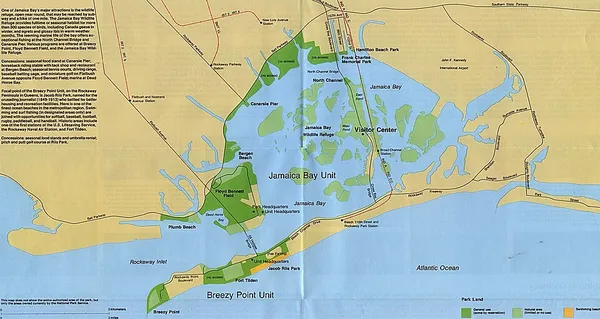
Jamaica Bay (also known as Grassy Bay) is an estuary on the southern portion of the western tip of Long Island, in the U.S. state of New York. The estuary is partially man-made, and partially natural. The bay connects with Lower New York Bay to the west, through Rockaway Inlet, and is the westernmost of the coastal lagoons on the south shore of Long Island. Politically, it is primarily divided between the boroughs of Brooklyn and Queens in New York City, with a small part touching Nassau County. The bay contains numerous marshy islands. It was known as Grassy Bay as late as the 1940s due the abundance of eelgrass in the bay, that was wiped out by an epidemic of parasitic labyrinthula zosterae that took out 90% of the eelgrass in the North Atlantic. Jamaica Bay is located adjacent to the confluence of the New York Bight and New York Bay, and is at the turning point of the primarily east-west oriented coastline of southern New England and Long Island and the north-south oriented coastline of the mid-Atlantic coast.
Also on this shelf
Economy of the Middle East.
Crna Reka Monastery.
See also
Uncatalogued shelfText from Wikipedia; plate via Wikimedia Commons. Text CC BY-SA 4.0; plate freely licensed (see Commons). Source record. Images and catalogue data are reproduced from open-access collections.