Maps and Exploration
East Patagonia, Tierra del Fuego and Strait of Magellan dispute
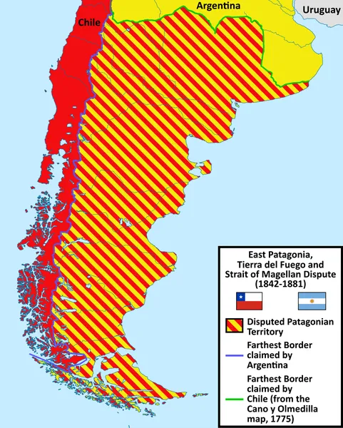
The East Patagonia, Tierra del Fuego and Strait of Magellan Dispute or the Patagonia Question was the boundary dispute between Argentina and Chile during the 19th century for the possession of the southernmost territories of South America on the basis of disagreements over the boundaries corresponding to the uti possidetis juris inherited from the Spanish Empire, which were partly due to contradictory background information. The extensive territory corresponds to approximately one million square kilometres, which represents 45% of the current surface of Argentina, all of the center and south of that country, and which, according to Chilean historiography, would have implied a loss for Chile of two-thirds of its nominal territory de jure. Both countries started effectively occupying different parts of the disputed land, Chile the Strait of Magellan and its nearby territory in the Santa Cruz River as well as the Neuquén Valley, and Argentina the Pampas land as well with Chubut settled with Welsh people. Both countries also started having discussions of the legal title of each country on the land inherited from the Spanish Empire, which motivated the signing of the 1856 treaty between both countries that affirmed that both countries were committed to apply the uti possidetis juris on the border; something which they both disagreed on was which territories had been inherited by each of the two nations. The decade of 1870 saw an intensification of the dispute in the southern part of Patagonia, which saw settlements from both countries in between of each other. The dispute was ended with the Boundary Treaty of 1881 between both countries which divided the territory. At the time of the signing, Chile had already triumphed at the Battle of Miraflores against Peru in the War of the Pacific (1879–1885), demonstrating its position of power; Argentina also started the Conquest of the Desert in 1878, intensifying it when Chile was in the war, occupying several parts of Patagonia.
Also on this shelf
Greater Downtown Miami.
Federal Building (Milwaukee, Wisconsin).
See also
Uncatalogued shelfText from Wikipedia; plate via Wikimedia Commons. Text CC BY-SA 4.0; plate freely licensed (see Commons). Source record. Images and catalogue data are reproduced from open-access collections.