Maps and Exploration
East Nusa Tenggara
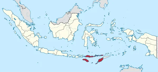
East Nusa Tenggara (Indonesian: Nusa Tenggara Timur; NTT; Indonesian pronunciation: [ˌnusa təŋˌɡara ˈtimʊr], lit. 'East Southeast Islands') is the southernmost province of Indonesia. It is the eastern portion of the Lesser Sunda Islands, facing the Indian Ocean in the south and the Flores Sea in the north, with a total land area of 46,378.11 km2. It consists of some 653 islands (excluding smaller unnamed ones), with the largest ones being Sumba (10,899.41 km2 in area), Flores (15,482.42 km2), and the western part of Timor (14,079.36 km2); the latter shares a land border with the separate nation of East Timor. Also substantial in land area are Alor (2,918.75 km2) and Lembata (1,263.77 km2). The province is subdivided into twenty-one regencies and the regency-level city of Kupang, which is the capital and largest city. Archaeological research shows that Liang Bua cave in East Nusa Tenggara has been inhabited by humans since about 190,000 years ago. The site was home to early humans, including Homo floresiensis, who were found in the cave's archaeological layers. East Nusa Tenggara is known for its natural environment and parks, including Komodo National Park, Labuan Bajo, Lake Kelimutu and the area's beaches. The province is rich in culture, with diverse tribes, languages, and traditions such as ikat weaving and the Pasola ceremony in Sumba. East Nusa Tenggara also has a strong missionary history, seen from the majority Catholic population and is one of the two Indonesian provinces where Roman Catholicism is the predominant religion, alongside South Papua. In addition, its marine ecosystem is very rich, making it a popular destination for divers.
Also on this shelf
Jacob Riis Park.
Guaraguao.
See also
Uncatalogued shelfText from Wikipedia; plate via Wikimedia Commons. Text CC BY-SA 4.0; plate freely licensed (see Commons). Source record. Images and catalogue data are reproduced from open-access collections.