Maps and Exploration
Jan Mayen
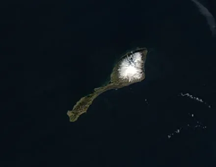
Jan Mayen (Urban East Norwegian: [jɑn ˈmɑ̀ɪən]) is a Norwegian volcanic island in the Arctic Ocean with no permanent population. It is 55 km (34 mi) long (southwest-northeast) and 377 km2 (146 sq mi) in area, partly covered by glaciers (an area of 114.2 km2 (44.1 sq mi) around the Beerenberg volcano). It has two parts: larger northeast Nord-Jan and smaller Sør-Jan, linked by a 2.5 km (1.6 mi) wide isthmus. It lies 600 km (370 mi) northeast of Iceland (495 km [305 mi] NE of Kolbeinsey), 500 km (310 mi) east of central Greenland, and 900 km (560 mi) northwest of Vesterålen, Norway. The island is mountainous, the highest summit being the Beerenberg volcano in the north. The isthmus is the location of the two largest lakes of the island, Sørlaguna (South Lagoon) and Nordlaguna (North Lagoon). A third lake is called Ullerenglaguna (Ullereng Lagoon). Jan Mayen was formed by the Jan Mayen hotspot and is defined by geologists as a microcontinent. Although administered separately, in the ISO 3166-1 standard, Jan Mayen and Svalbard are collectively designated as Svalbard and Jan Mayen, with the two-letter country code "SJ". It was also given the Internet domain of .sj. However, the domain is not in use and Norway's .no is used in its place. Jan Mayen is home to Beerenberg, which is the northernmost subaerial active volcano in the world.
Also on this shelf
Holodomor.
Chertsey.
See also
Uncatalogued shelfText from Wikipedia; plate via Wikimedia Commons. Text CC BY-SA 4.0; plate freely licensed (see Commons). Source record. Images and catalogue data are reproduced from open-access collections.