Maps and Exploration
Borneo
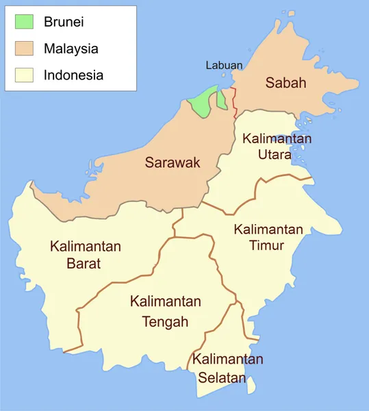
Borneo () is the third-largest island in the world, with an area of 748,168 km2 (288,869 sq mi), and population of 23,053,723 (2020 national censuses). Situated at the geographic centre of Maritime Southeast Asia, it is one of the Greater Sunda Islands, located north of Java, west of Sulawesi, and east of Sumatra. The island is crossed by the equator, which divides it roughly in half. In Indonesia, the island is also known as Kalimantan, which is also the name of the Indonesian region located on the island. The rest of the island consists of East Malaysia and Brunei. The geology of Borneo was formed beginning in the Mesozoic. It formed part of Sundaland, a region connected to mainland Asia, until it became isolated by sea level rise at the end of the Last Glacial Period. With seven unique ecoregions, including large expanses of some of the oldest tropical rainforests in the world, Borneo is rich in biodiversity and endemic species. Archaeological evidence indicates that Borneo has been inhabited by humans for tens of thousands of years. The island is home to hundreds of Indigenous communities, cultures and languages, many of which have traditionally been grouped under the broad term "Dayak". Trading settlements on Borneo were connected to regional maritime networks by the first millennium CE. Several empires, kingdoms and sultanates subsequently emerged around the island's coasts. This includes the Javanese Majapahit, the Sultanate of Brunei, which held influence over much of coastal Borneo and parts of the southern Philippines at its peak in the 15th century, and the Sultanate of Sulu, which became an important maritime power in the Sulu Sea and northeastern Borneo. The island's interior, however, remained politically diverse and was largely governed by numerous Indigenous communities and local systems of authority rather than by a single state. Parts of the island were later colonised by Britain, Netherlands and Japan. Since decolonisation, Borneo has been politically divided among three sovereign states. Approximately 73% of the island forms part of Indonesia, comprising the five provinces collectively known as Kalimantan. About 26% consists of the Malaysian states of Sabah and Sarawak, while the sovereign state of Brunei occupies a small area on the island's northwestern coast.
Also on this shelf
Athelstan Spilhaus.
Boca Chita Key Historic District.
See also
Uncatalogued shelfText from Wikipedia; plate via Wikimedia Commons. Text CC BY-SA 4.0; plate freely licensed (see Commons). Source record. Images and catalogue data are reproduced from open-access collections.