Maps and Exploration
Gerardus Mercator
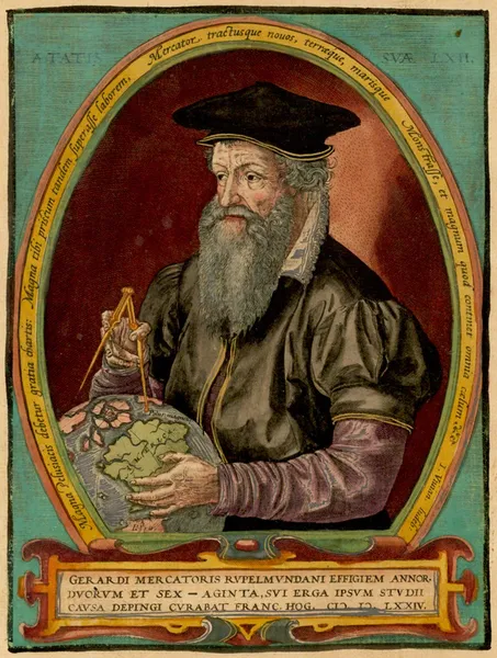
Gerardus Mercator (; 5 March 1512 – 2 December 1594) was a Flemish geographer, cosmographer and cartographer. He is most renowned for creating the 1569 world map based on a new projection which represented sailing courses of constant bearing (rhumb lines) as straight lines—an innovation that is still employed in nautical charts. Mercator was a notable maker of globes and scientific instruments. In addition, he had interests in theology, philosophy, history, mathematics, and geomagnetism. He was also an accomplished engraver and calligrapher. Unlike other great scholars of the age, he travelled little and his knowledge of geography came from his library of over a thousand books and maps, from his visitors and from his vast correspondence (in six languages) with other scholars, statesmen, travellers, merchants and seamen. Mercator's early maps were in large formats suitable for wall mounting but in the second half of his life, he produced over 100 new regional maps in a smaller format suitable for binding into his Atlas of 1595. This was the first appearance of the word "atlas" in connection with maps, but Mercator did not intend the word to mean a collection of maps; it was a neologism for a treatise (Cosmologia) on the creation, history and description of the universe. He chose the word as a reference to a legendary king of Mauretania who was traditionally considered the first great geographer. A large part of Mercator's income came from sales of terrestrial and celestial globes. For sixty years they were considered the finest in the world, and were sold in such numbers that there are many surviving examples. This was a substantial enterprise involving the manufacture of the spheres, printing the gores, building substantial stands, packing and distributing them all over Europe. He was also renowned for his scientific instruments, particularly his astrolabes and astronomical rings used to study the geometry of astronomy and astrology. Mercator wrote on geography, philosophy, chronology and theology. All of the wall maps were engraved with copious text on the region concerned. As an example, the famous world map of 1569 is inscribed with over five thousand words in fifteen legends.
Also on this shelf
Leicester Square.
Dong River (China).
See also
Uncatalogued shelfText from Wikipedia; plate via Wikimedia Commons. Text CC BY-SA 4.0; plate freely licensed (see Commons). Source record. Images and catalogue data are reproduced from open-access collections.