Maps and Exploration
Geography of Greenland
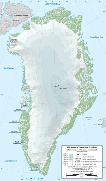
Greenland is located between the Arctic Ocean and the North Atlantic Ocean, northeast of Canada and northwest of Iceland. The territory comprises the island of Greenland—the largest island in the world—and more than a hundred other smaller islands (see alphabetic list). Greenland has a 1.2-kilometre-long (0.75 mi) border with Canada on Hans Island. A sparse population is confined to small settlements along certain sectors of the coast. Greenland possesses the world's second-largest ice sheet. Greenland sits atop the Greenland plate, a subplate of the North American Plate. The Greenland craton is made up of some of the oldest rocks on the face of the earth. The Isua greenstone belt in southwestern Greenland contains some of the oldest dated rocks on Earth, dated at 3.7–3.8 billion years old. The vegetation is generally sparse, with the only patch of forested land being found in Nanortalik Municipality in the extreme south near Cape Farewell. The climate is arctic to subarctic, with cool summers and cold winters. The terrain is mostly a flat but gradually sloping icecap that covers all land except for a narrow, mountainous, barren, rocky coast. The lowest elevation is sea level and the highest elevation is the summit of Gunnbjørn Fjeld, the highest point in the Arctic at 3,694 metres (12,119 ft). The northernmost point of the island of Greenland is Cape Morris Jesup, discovered by Admiral Robert Peary in 1900. Natural resources include zinc, lead, iron ore, coal, molybdenum, gold, platinum, uranium, hydropower and fish.
Also on this shelf
Elizabethan era.
1976 United States presidential election.
See also
Uncatalogued shelfText from Wikipedia; plate via Wikimedia Commons. Text CC BY-SA 4.0; plate freely licensed (see Commons). Source record. Images and catalogue data are reproduced from open-access collections.