Maps and Exploration
Greater Downtown Miami
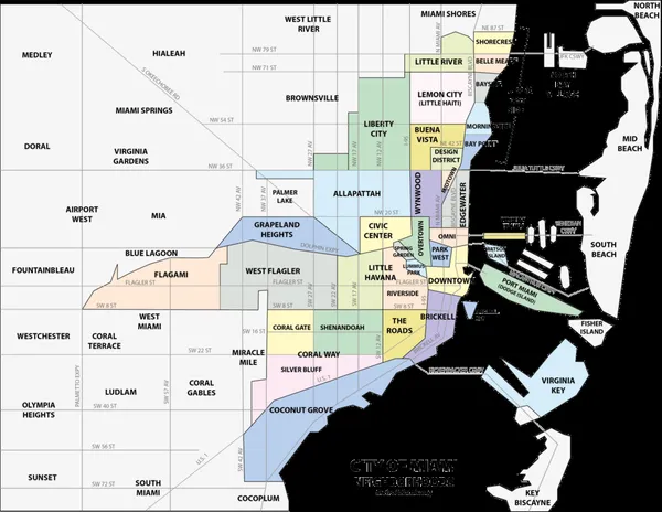
Greater Downtown Miami is the urban core of Miami, Florida, United States. The city's greater downtown region consists of the Central Business District, Brickell, the Historic District, Government Center, the Arts & Entertainment District, and Park West. It is divided by the Miami River and is bordered by Midtown Miami's Edgewater, and Wynwood sections to its north, Biscayne Bay to its east, the Health District and Overtown to its west, and Coconut Grove to its south. It serves as the core of the Miami metropolitan area, the nation's sixth-largest and world's 65th-largest metropolitan area with a population of 6.158 million people. Brickell Avenue and Biscayne Boulevard are the main north–south roads, and Flagler Street is the main east–west road. The areas perimeters are defined by the Miami Downtown Development Authority as the 3.8-square-mile (9.8 km2) area east of Interstate 95 between Rickenbacker Causeway to the south and the Julia Tuttle Causeway, which connects Miami and Miami Beach, to the north. The area is a cultural, financial, and commercial center of the Miami metropolitan area, tracing its present-day history back to the 19th century. It currently has the third greatest concentration of high-rises in the United States and is home to many major museums, parks, education centers, banks, company headquarters, courthouses, government offices, theaters, shops and many of the oldest buildings in the city.
Also on this shelf
El Rocío.
Cocos Island.
See also
Uncatalogued shelfText from Wikipedia; plate via Wikimedia Commons. Text CC BY-SA 4.0; plate freely licensed (see Commons). Source record. Images and catalogue data are reproduced from open-access collections.