Geology and Minerals
Geography of Ghana
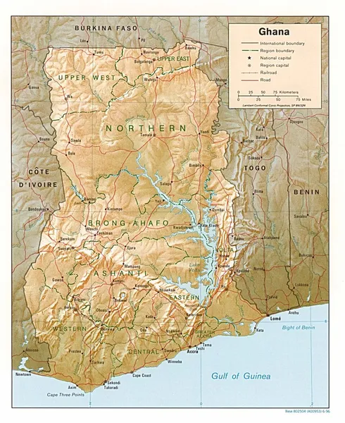
Ghana is a West African country in Africa, along the Gulf of Guinea. Ghana encompasses plains, low hills, rivers, Lake Volta, the world's largest artificial lake, Dodi Island and Bobowasi Island on the south Atlantic Ocean coast of Ghana. Ghana can be divided into four different geographical ecoregions. The coastline is mostly a low, sandy shore backed by plains and scrub and intersected by several rivers and streams. The northern part of Ghana features high plains. South-west and south-central Ghana is made up of a forested plateau region consisting of the Ashanti uplands and the Kwahu Plateau. The hilly Akwapim-Togo ranges are found along Ghana's eastern international border. The Volta Basin takes up most of south-central Ghana and Ghana's highest point is Mount Afadja which is 885 m (2,904 ft) and is found in the Akwapim-Togo ranges. The climate is tropical and the eastern coastal belt is warm and comparatively dry, the south-west corner of Ghana is hot and humid, and the north of Ghana is warm and wet. Lake Volta, the world's largest artificial lake, extends through small portions of south-eastern Ghana and many tributary rivers such as the Oti and Afram rivers flow into it. The northernmost part of Ghana is Pulmakom and the southernmost part of Ghana is Cape Three Points near Axim. Ghana lies between latitudes 4° and 12°N. South Ghana contains evergreen and semi-deciduous forests consisting of trees such as mahogany, odum, ebony and it also contains much of Ghana's oil palms and mangroves with shea trees, baobabs and acacias found in the northern part of Ghana. Its southernmost coast at Cape Three Points is 4° 30' north of the equator. From here, the country extends inland for some 670 kilometres (420 mi) to about 11° north. The distance across the widest part, between longitude 1° 12' east and longitude 3° 15' west, measures about 560 kilometres (350 mi). The Greenwich Meridian, which passes through London, also traverses the eastern part of Ghana at Tema.
Also on this shelf
Catoctin Formation.
Geography of Portugal.
See also
Uncatalogued shelfText from Wikipedia; plate via Wikimedia Commons. Text CC BY-SA 4.0; plate freely licensed (see Commons). Source record. Images and catalogue data are reproduced from open-access collections.