Geology and Minerals
Geology of the United States
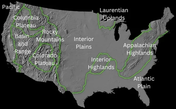
The richly textured landscape of the United States is a product of the dueling forces of plate tectonics, weathering and erosion. Over the 4.5 billion-year history of the Earth, tectonic upheavals and colliding plates have raised great mountain ranges while the forces of erosion and weathering worked to tear them down. Even after many millions of years, records of Earth's great upheavals remain imprinted as textural variations and surface patterns that define distinctive landscapes or provinces. The diversity of the landscapes of the United States can be easily seen on the shaded relief image to the right. The stark contrast between the 'rough' texture of the western US and the 'smooth' central and eastern regions is immediately apparent. Differences in roughness (topographic relief) result from a variety of processes acting on the underlying rock. The plate tectonic history of a region strongly influences the rock type and structure exposed at the surface, but differing rates of erosion that accompany changing climates can also have profound impacts on the land. There are twelve main geological provinces in the United States: Pacific, Columbia Plateau, Basin and Range, Colorado Plateau, Rocky Mountains, Laurentian Upland, Interior Plains, Interior Highlands, Appalachian Highlands, Atlantic Plain, Alaskan, and Hawaiian. Each province has its own geologic history and unique features. This article will describe each province in turn.
Also on this shelf
Ardatov, Nizhny Novgorod Oblast.
Lake Taupō.
See also
Uncatalogued shelfText from Wikipedia; plate via Wikimedia Commons. Text CC BY-SA 4.0; plate freely licensed (see Commons). Source record. Images and catalogue data are reproduced from open-access collections.