Geology and Minerals
1980 eruption of Mount St. Helens
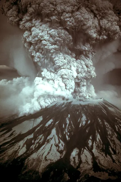
On May 18, 1980, at 8:32 a.m., Mount St. Helens in Skamania County, Washington, United States, experienced a catastrophic explosive eruption which had a volcanic explosivity index of 5. It was the first to occur in the contiguous United States since the much smaller 1915 eruption of Lassen Peak in California. The main eruption was preceded by a series of volcanic explosions, pyroclastic flows, and phreatic blasts beginning in March 1980. It has often been considered the most disastrous volcanic event in U.S. history. The eruption was preceded by a series of earthquakes and steam-venting episodes caused by an injection of magma at shallow depth below the volcano that created a large bulge and a fracture system on the mountain's north slope. An earthquake at 8:32:11 am PDT (UTC−7) on May 18, 1980, caused the entire weakened north face to slide away, a sector collapse which was the largest subaerial landslide in recorded history. This allowed the partly molten rock, rich in high-pressure gas and steam, to suddenly explode northward toward Spirit Lake in a hot mix of lava and pulverized rock, overtaking the landslide. An eruption column rose 80,000 feet (24 km; 15 mi) into the atmosphere and deposited ash in 11 U.S. states and various Canadian provinces. At the same time, snow, ice, and several entire glaciers on the volcano melted, forming a series of large lahars (volcanic mudslides) that reached as far as the Columbia River, nearly 50 miles (80 km) to the southwest. Less severe outbursts continued into the next day, only to be followed by other large, but not as destructive, eruptions later that year. The thermal energy released during the eruption was equal to 26 megatons of TNT. About 57 people were killed, including innkeeper and World War I veteran Harry R. Truman, photographers Reid Blackburn and Robert Landsburg, and volcanologist David A. Johnston. Hundreds of square miles were reduced to wasteland, causing over $1 billion in damage (equivalent to $3.5 billion in 2024). Thousands of animals were killed, and Mount St. Helens was left with a crater on its north side. At the time of the eruption, the summit of the volcano was owned by the Burlington Northern Railroad, but the United States Forest Service acquired the land from the railroad after the eruption. The area was later preserved in the Mount St.
Also on this shelf
California Volcano Observatory.
Antofalla.
See also
Uncatalogued shelfText from Wikipedia; plate via Wikimedia Commons. Text CC BY-SA 4.0; plate freely licensed (see Commons). Source record. Images and catalogue data are reproduced from open-access collections.