Geology and Minerals
Geography of Canada
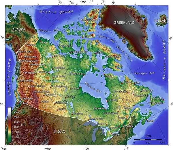
Canada has a vast geography that occupies much of the continent of North America, sharing a land border with the contiguous United States to the south and the U.S. state of Alaska to the northwest. Canada stretches from the Atlantic Ocean in the east to the Pacific Ocean in the west; to the north lies the Arctic Ocean. Greenland is to the northeast, with a shared border on Tartupaluk/Hans Island. To the southeast Canada shares a maritime boundary with France's overseas collectivity of Saint Pierre and Miquelon, the last vestige of New France. By total area (including its waters), Canada is the second-largest country in the world, after Russia. By land area alone, however, Canada ranks fourth, the difference being due to it having the world's largest proportion of freshwater lakes. Of Canada's 13 provinces and territories, only two are landlocked (Alberta and Saskatchewan), while the other 11 all directly border one of three oceans. Canada is home to the world's northernmost settlement, Canadian Forces Station Alert, on the northern tip of Ellesmere Island—latitude 82.5°N—which lies 817 kilometres (508 mi) from the North Pole. Much of the Canadian Arctic is covered by ice and permafrost. Canada has the longest coastline in the world, with a total length of 243,042 kilometres (151,019 mi); additionally, its border with the United States is the world's longest land border, stretching 8,891 kilometres (5,525 mi). Three of Canada's Arctic islands, Baffin Island, Victoria Island, and Ellesmere Island, are among the 10 largest in the world. Canada can be divided into seven physiographic regions: the Canadian Shield, the Interior Plains, the Great Lakes–St. Lawrence Lowlands, the Appalachian region, the Western Cordillera, Hudson Bay Lowlands, and the Arctic Archipelago. Canada is also divided into 15 terrestrial and five marine ecozones, encompassing over 80,000 classified species of life. Since the end of the last glacial period, Canada has consisted of eight distinct forest regions, including extensive boreal forest on the Canadian Shield; 42 percent of the land acreage of Canada is covered by forests (approximately 8 percent of the world's forested land), made up mostly of spruce, poplar, and pine. Canada has over 2,000,000 lakes—563 greater than 100 km2 (39 sq mi)—which is more than any other country, containing much of the world's fresh water.
Also on this shelf
Alum Shale Formation.
Bituminous coal.
See also
Uncatalogued shelfText from Wikipedia; plate via Wikimedia Commons. Text CC BY-SA 4.0; plate freely licensed (see Commons). Source record. Images and catalogue data are reproduced from open-access collections.