Astronomy and Space
Earth observation satellite
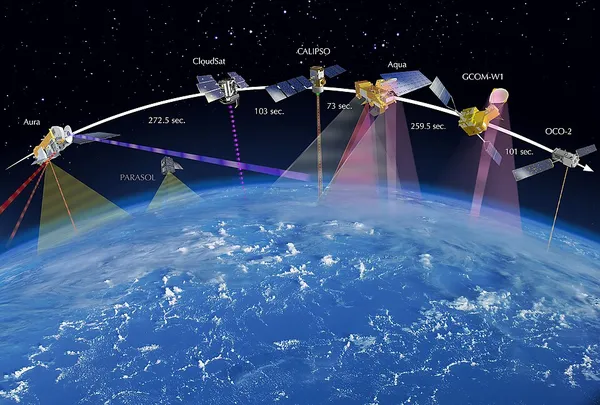
An Earth observation satellite or Earth remote sensing satellite is a satellite used or designed for Earth observation (EO) from orbit, including spy satellites and similar ones intended for non-military uses such as environmental monitoring, meteorology, cartography and others. The most common type are Earth imaging satellites, that take satellite images, analogous to aerial photographs; some EO satellites may perform remote sensing without forming pictures, such as in GNSS radio occultation. The first occurrence of satellite remote sensing can be dated to the launch of the first artificial satellite, Sputnik 1, by the Soviet Union on October 4, 1957. Sputnik 1 sent back radio signals, which scientists used to study the ionosphere. The United States Army Ballistic Missile Agency launched the first American satellite, Explorer 1, for NASA's Jet Propulsion Laboratory on January 31, 1958. The information sent back from its radiation detector led to the discovery of the Earth's Van Allen radiation belts. The TIROS-1 spacecraft, launched on April 1, 1960, as part of NASA's Television Infrared Observation Satellite (TIROS) program, sent back the first television footage of weather patterns to be taken from space. In 2008, more than 150 Earth observation satellites were in orbit, recording data with both passive and active sensors and acquiring more than 10 terabits of data daily. By 2021, that total had grown to over 950, with the largest number of satellites operated by US-based company Planet Labs. Most Earth observation satellites carry instruments that should be operated at a relatively low altitude. Most orbit at altitudes above 500 to 600 kilometers (310 to 370 mi). Lower orbits have significant air-drag, which makes frequent orbit reboost maneuvers necessary. The Earth observation satellites ERS-1, ERS-2 and Envisat of European Space Agency as well as the MetOp spacecraft of EUMETSAT are all operated at altitudes of about 800 km (500 mi). The Proba-1, Proba-2 and SMOS spacecraft of European Space Agency are observing the Earth from an altitude of about 700 km (430 mi). The Earth observation satellites of UAE, DubaiSat-1 & DubaiSat-2 are also placed in Low Earth orbits (LEO) orbits and providing satellite imagery of various parts of the Earth. To get global coverage with a low orbit, a polar orbit is used.
Also on this shelf
Isaac Asimov.
1955 in spaceflight.
See also
Uncatalogued shelfText from Wikipedia; plate via Wikimedia Commons. Text CC BY-SA 4.0; plate freely licensed (see Commons). Source record. Images and catalogue data are reproduced from open-access collections.