Ancient World
Horvat Tefen
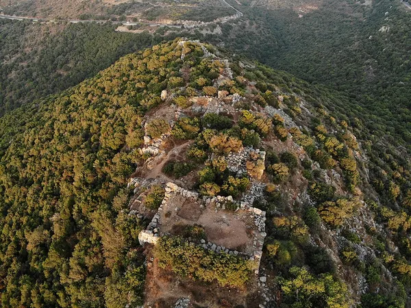
Horvat Tefen (Hebrew: חורבת תפן) or Qal'at et-Tufaniya (Arabic: قلعة الطفانية, lit. 'castle of the flood'), alternatively Tefen Fortress, is an archaeological site in the Western Galilee region of northern Israel. Located on a mountain ridge approximately 16 kilometres (9.9 mi) from the coastal city of Acre, the site contains the remains of a short-lived hilltop fort dating to the early 1st century BCE. Excavations conducted in 2019 have made it possible to identify the site as a Hasmonean military installation. The fortification follows the narrow and irregular contours of the hilltop. Its architectural layout consists of seven rectangular towers of varying sizes, linked by curtain walls to form a continuous defensive perimeter. Access to the interior was limited to a single western gate, which featured a double-leaved door secured by sliding bar mechanisms. To sustain its garrison in an area devoid of natural springs, the fort relied on four large reservoirs. The site was first documented in the 19th century by explorers such as Victor Guérin and members of the Survey of Western Palestine (SWP). Surveys conducted throughout the 20th century suggested it was a Hellenistic initiative by the people of Acre (then the Phoenician city of Akko-Ptolemais), who built it as a defensive measure against the expanding Hasmonean Kingdom of Judea following its conquest of Galilee. However, discoveries from the 2019 excavation, including the finding of overwhelmingly Hasmonean coins minted during the reign of Alexander Jannaeus in the fort's foundational levels, indicate that the site was constructed by the Hasmoneans. The purpose of the fort is now believed to have been securing the northwestern border of the Hasmonean state against Acre. Following several centuries of abandonment, the site saw a revival during the Byzantine period (5th–7th centuries CE), when it was repurposed for agricultural use, likely serving as a winepress, as indicated by the discovery of numerous coarse tesserae and Byzantine pottery.
Also on this shelf
Ahwat.
Gerakas.
See also
Uncatalogued shelfText from Wikipedia; plate via Wikimedia Commons. Text CC BY-SA 4.0; plate freely licensed (see Commons). Source record. Images and catalogue data are reproduced from open-access collections.